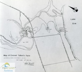
Map of Colonel Talbot's Farm
https://heritagecollections.elgin.ca/link/archives169536
- Museum / Archive
- Elgin County Archives
- Part Of
- Steve Peters Papers
- Description Level
- Item
- GMD
- textual records
- Date Range
- June 16, 1813
- Accession Number
- 2018-23
- Storage Location
- R13 S2 Sh1 B7 F11 7
- Museum / Archive
- Elgin County Archives
- Part Of
- Steve Peters Papers
- Description Level
- Item
- Accession Number
- 2018-23
- Storage Room
- Archives Storage Rm. 110
- Storage Location
- R13 S2 Sh1 B7 F11 7
- GMD
- textual records
- Date Range
- June 16, 1813
- Physical Description
- 1 print : b&w ; 19.5 x 22 cm
- Scope and Content
- Photographic print of a Map of Colonel Talbot's Farm, redrawn by Lt. B.D. Sim, in October 1979.
- Name Access
- Peters, Steve
- St. Thomas (Ont.)
- Talbot Estate
Images

{{ server.message }}
{{ server.message }}